Tuesday, October 13, 2020

Desperately Seeking Solitude - Grand Canyon National Park


I heard a faint hint of a chime as I was driving down the road. I had received an email, a text or some other notification. Could it be? Was it possible? My heart raced at the prospect. My palms grew moist. Ok, I made that last part up, but I was excited. It felt like one of my first days of online dating. You hear a chime, wondering if you just got "liked" by some total babe. I digress.

I had been on the Grand Canyon hikers Facebook page and had read that folks had been receiving letters from the Backcountry information center, about permit requests. Some were happy, and others not so much. It had been almost a week and I hadn't heard anything. No news is good news, I guess.

 I'd hoped that I hadn't just received the proverbial "Dear John" or "Dear Josh", email as it were. After what seemed an eon, I arrived at my destination. I quickly scanned my phone and saw that I had an email from the BIC. Boom!! I closed my eyes and quickly realized that I would soon be backpacking in the Canyon!


Now, Bianca and I had been banging out paddling, camping, cycling, and backpacking trips for much of the spring and summer, whenever we could. But, what I was really waiting for was the Granddaddy of them all, in my opinion, Grand Canyon National Park. We'd done some incredible day hikes in the Canyon, but I hadn't backpacked the Canyon in a couple of years. What with tumors, surgeries, radiation, Covid and forest fires, either I had been physically unable or things had been all but completely shut down at the park. I hadn't backpacked in the Canyon since early 2018. I hadn't been in the Canyon at all, since completing an awesome, long day hike of the Hermit Loop, in October 2020. That was an entire week ago! Our November 2020, three day Phantom Ranch trip had been unceremoniously cancelled, and no new permit requests were being received. Even trips that were already permitted were being cancelled. Mather CG on the rim was closed down to new permits, as well. Well, crud!! 

Not letting such obstacles get in the way, we'd made do with excursions to other excellent destinations. Bianca has informed me on a number of occasions that it's actually ok to explore places other than GCNP and that exploring other states is ok, too. Wait, what? We'd had some serious exploration of the Colorado River, in a few different locations. We'd explored a chunk of Northern Arizona, here, and a swath of Northern Arizona, there, and the cooler summer climes that it offers. We'd hammered out a trip or two on the Mogollon Rim. We'd had a ton of fun. We had no less than six additional trips on the books for the rest of the summer and into the fall. Still, something was missing. My heart strings felt a constant tug, much like a fishing line with a giant bass hooked on it. I don't know, tractor-beam like, if you will? That tractor beam was pulling me, and my backpack, towards the Big Ditch.

After what seemed like an eternity, my daily glimpse at the GCNP website indicated that new permit requests would be welcomed, shortly. I knew that I'd get my request in as soon as possible. I needed to figure out what area I would seek a permit in. 

I knew that there were probably thousands of folks also seeking a permit, so I didn't want to have anything to do with the corridor trails. I've done them a ton of times and didn't feel the need to try for one of those permits, as the majority of folks would be seeking them. Many of the other areas that I wanted to seek out required more than a weekend, in fact many of them would require 3-4 days at a minimum. In short, I needed a quick trip to fill a weekend, that would pack a punch. I came up with the perfect solution. Cape Solitude would be it. I had been meaning to get there for years, and this was the perfect opportunity.

Cape Solitude is at the far Eastern end of the canyon and abuts the Navajo nation. It is rarely visited. The hike actually never leaves the rim. It's a 15 mile hike to the rim. When one reaches Cape Solitude, one has an overhead view of the confluence of the Colorado River and the Little Colorado River. It's an incredibly beautiful site and is a sacred area to the Native tribes in the region. I'd been fortunate enough to visit the confluence in person on a river trip in 2005 and came close on a backpacking trip in 2017. We'd had to abandon the attempt a few miles short, on the Beamer trail, due to poor planning on my part. It's a two day trip to get there and a two day trip to get out. We just didn't have enough time budgeted. Some day, I'll get there again, via the Beamer. 

In this instance we'd be camping on the rim above the confluence with the place all to ourselves. We'd hike in early one morning. We'd set up camp and enjoy the views and explore a few vistas on the rim. The next morning we'd hike out. We'd have to carry all of our water for the entire trip, as we'd encounter no water sources on the way. This would be a true wilderness experience.

On the big day, we loaded up the rig as as soon as I got out of work, and hit the road. Thankfully, the trip to Williams, yeah that Williams, was uneventful. Bianca was in charge of our accommodations and thus we were not in the L'hotel de Fleabag, as I had been the previous weekend. 


Dang, we actually had in-room coffee! While it wasn't anything special, it surely was serviceable. We awoke at the rather civil time of 5:00 AM, versus the 3:00 AM wakeup that I had last weekend. We'd be able to drive straight to the trailhead and wouldn't need to take a shuttle, thankfully. By the time we got on the road, McDonalds was open and we were able to acquire additional coffee and some hot breakfast sandwiches. Hallelujah!

We got to the trailhead around 8:00, much later than I would have preferred, by about two hours. We geared up and eventually hit the trail around 8:45. I was nervous about such a late start as that would put more of our hiking in the heat of the day. Though the forecast only called for highs in the low 70s, it still felt pretty warm. I later learned that temps were 6-8 degrees higher. Ultimately, that would combine with a couple of other factors to seal the trip's fate.


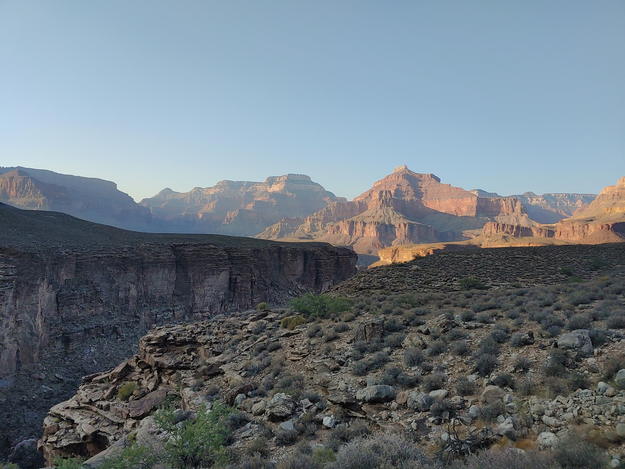
The first three miles of the journey would be on Cedar Mountain road. That extremely rough road would take us to the actual Cape Solitude trailhead. Some folks use a high clearance vehicle to travel to the trailhead. We walked. After the initial mile, we encountered a series of switchbacks over several miles, which took us down to the platform that we'd be spending the balance of our journey on. Cedar Mountain, a flat topped mountain became visible. That mountain would be a constant companion for the first half of our journey.


The Desert View Watchtower, visible on top of the ridge, above. An iconic structure and tourist attraction at GCNP, we'd see it standing watch over us for the first half of our pilgrimage. 


Soaking in one of the first excellent views of the Canyon on this trip. I believe that that's the canyon that the Tanner Trail is in.


We left two water caches on the way in. We left 1.5 liters at the beginning of the toughest part of the final climbout as we thought that we might need to tank up prior to taking on that challenge. We left an additional 1.5L at the base of the switchbacks. Sadly, though I shed about 7 lbs of water weight, I still had over 50 lbs on my back. It was a heavy load and made for quite the challenge to put my pack on after taking it off. This would also be a contributing factor to our primary trip objective not being met.


Finally, we made it to the end of the road and to the Cape Solitude trail. I was a bit alarmed as it had taken an inordinate amount of time to get to this point, which was just three miles into our fifteen mile day. I wrote off my concerns, as sometimes it takes time to build up momentum on a trip. You're stopping and taking more pictures and adjusting your pack, etc. I figured we'd speed up and "catch up" to where we'd be back on track.


For the first five miles of the trip, we were in a Juniper tree forest. I've always loved those trees, especially the big, thick, gnarly looking ones. The trail was easy to follow in some areas and pretty obscure in others. We had a map and a GPS track we were following. That made it pretty easy to get back on track if we lost the trail.


A quick break to have a snack and rearrange a few things. We didn't linger during any of our breaks, but they nonetheless add up. 


A lot of the trail was gnarly and rocky. We didn't realize it until the next day, but we were traveling, gently, downhill for most of the day. That gentle downhill, coupled with very heavy packs, was a contributor to our slow pace. Heavy packs and downhill hiking hammers the knees.


The first five to six miles of the hike were spent in the aforementioned Juniper forest, as well as being mostly in a dry creek bottom. This was a unique hike for me in terms of Grand Canyon experiences.


We began to emerge into a different environment of rolling hills covered in prairie grass and sage brush. The sage had a wonderful aroma. The scenery a tad more pedestrian. Yes, I know, I'm sort of a Grand Canyon snob.


Working our way around Cedar Mountain. 


As the day wore on, my right big toe began to feel as though it was on fire. The last thing I wanted to do what shed my pack and sit down in the middle of a prairie devoid of anything but grass, take my shoe off and use up even more precious time addressing the problem. However, the problem would only get worse and I'd end up with a nasty, misery inducing blister if I didn't deal with it. I took the boot and sock off and cut a piece of leukotape to cover the hot area. I then rubbed the whole foot in Aquaphor. I put everything back together and we continued the journey. The problem was immediately resolved, thankfully.


We went over a small rise, and way off in the distance we could see the rim of the Canyon. We were not able to see where Cape Solitude was. Anything we could see seemed days away. It was slightly discouraging. 


We eventually made the approach to the Navajo Nation. The trail enters the nation for a short while and then comes back onto the National Park. A permit is required to enter the Nation. I didn't have one. I had heard that you could just follow the fenceline until the trail reentered the Park. We did just that.


Taking a quick break near the Nation. I was really starting to feel pretty physically hammered at this point and we still had around five miles to go. 


As the miles, slowly, ebbed away, my concern about our pace was definitely back at the forefront. I was concerned about our water situation. I hadn't budgeted enough water to last as many hours as we had been and were likely to be out there. Not that we could have possibly carried more. If tomorrow was the same as it had been today, we'd be in real trouble. All of our meals needed water in order to be rehydrated and we'd also hoped to enjoy coffee in the morning. 

As we hit the 12 mile mark, a scan of the map and the GPS unit indicated that we had about three miles left, which at our current pace would have been two hours. It would have been two more hours of increased water needs, as well as six more miles of travel to get back to the car. Three miles to Cape Solitude and three miles back to where we currently were. 

The prospect of continuing to move forward, possibly digging whatever hole we were in even deeper, didn't entice me. After soliciting Bianca's thoughts, I made the decision to abandon the effort to get to Cape Solitude. I felt like it was my duty to make the best decision to keep us safe. Could we most likely have survived had we pressed on? Of course. However, I wasn't comfortable with the margin for error or enduring what I was sure would have been a miserable 24 hours or so, until we reached our water cache.

Bianca was disappointed, as was I. It sucks to fail. It's always better to live to fight another day, though. We'll have another shot at it, if we are so inclined.

We found a place to set up camp, right next to the trail. It wasn't exactly what we had in mind, but it would do.


Within minutes, camp was setup. I started preparing dinner. We were both famished. Mountain House Chili Mac was on the menu. I had carried in half of a baguette to accompany the meal. It really hit the spot. We enjoyed a beautiful sunset. At that point, the sleeping bags were calling. We had nothing else to do. We were asleep by 7:30 despite a pretty strong thirst. Unfortunately, I woke up just before midnight. I drifted in and out of sleep until 5:00 AM at which point I'd had enough. I knew that it would be an hour until daylight and I intended to be hiking at that time.

I roused Bianca from her sleep, feeling a bit guilty, and let her know the plan. She was less than thrilled, but gamely got up and got to work. We didn't say much as we broke down camp and probably each contemplated the day ahead. It's at times like this where you truly appreciate a partner with a positive outlook on life. We both downed a chocolate mocha caffeine infused Clif bar for breakfast and 1/2 liter of water each. 


The sunrise was absolutely spectacular! Wow! The temps were in the 30s and it was pretty breezy. We didn't dilly dally and were making tracks a tick or two past 6:00. Despite my overall dehydration and a bit of soreness/stiffness from the previous day's efforts, I felt strong and ready to crank out some serious miles.


We enjoyed a beautiful morning. All of the previous day's frustrations were put behind us. With temps 20-30 degrees cooler, as well as a significantly lighter pack due to our decrease in water and food, we were flying and doing 2.5 to 3 MPH. This was what I had envisioned the previous day.


Within seemingly no time, we were once again approaching the Nation. We were definitely a couple of hours ahead of yesterday's pace. It felt great! Within an hour, we'd hit our first cache site. We arrived to find our water and it was really cold. For the first time all weekend, I drank with abandon, and deeply. It was very satisfying. 


Reaching the end of the trail and knowing we had just three road miles to go, was a great feeling. I knew that we had a cooler full of ice cold drinks in the car. I was looking forward to that. I felt incredibly energetic and could have run those last three miles.


It was great to reach the car. We quickly changed clothes and got on the road for Flagstaff. We made an intermittent stop in Tusayan for some Starbucks! We were in serious need of caffeine. Next stop would be Flagstaff for some grub!


If I had known on Saturday that we'd have such an easy time of it on Sunday, it might have changed my decision to stop. At the time, I just didn't know, so I definitely don't regret the decision. I could only make my decision based on the day we'd just experienced. In the end, it was still a great adventure, we just didn't get to the piece de resistance.

If we do this again, and I'd like to, I'd so some things differently. I'd choose to go in late November or December, to guarantee that we'd hike in cold weather, therefore reducing water needs. I'd consider the rental of a high clearance vehicle to haul all of our water and gear to the end of Cedar Mountain Road. From there I'd hike in the day before and cache a bunch of water or even possibly set up a spike camp. I'd really like to go back and get this done!

Friday, October 9, 2020

Hermit Loop Dayhike - GCNP


You've gotta be s@*%$ting me, I mumbled to myself. My head was on a swivel and I was looking back and forth, just hoping and wanting, and desperately looking for a little neon filled "Open" sign. Give it up, Bro!! It ain't happening and you know it! You knew it yesterday for crying out loud. Just reach your hand into the cooler, and be done with it. Let's go. we've got stuff to get done. Well, crud.

I was in the lovely little hamlet of Williams, AZ. Like millions before me, I was cruisin down good ole Route 66. I sure as heck wasn't getting my kicks, at least my caffeine kicks. It was 3:15 AM and all I wanted was a hot cup of coffee and a few breakfast sandwiches or burritos, or whatever hot breakfast I could get. The hotel de fleabag, where I was staying for the weekend, had the effrontery to not even have in-room coffee makers. Seriously? 

Luckily, ever the boyscout, I'd had the foresight to prepare for such an unfortunate eventuality. The previous day, on my way to work, I'd picked up a half dozen egg mcmuffins and the like, and had put them on ice, knowing that I might need them. I'd also picked up a couple of cans of Starbucks double whatever, so that I'd at least be able to down some caffeine to get me going. 

Why was I in Williams? Why was I up at 3 AM? Stop me if you've heard this one before. So, this weekend I was supposed to be camping with my good friends, the Touchstones, in the Sedona area. We'd had reservations for months. We were going to do some paddling on the Verde, and some mountain biking. Well, one look at the forecast once again led to another cancellation. The weather was going to be way too hot for tent camping. At this point, it was reaching ridiculousness. What to do?

I knew that Bianca was unavailable for the weekend, so that gave me the option of doing a trip that I knew might not necessarily be well suited to her, and specifically to her balky knee. Bianca is tough and very fit and can certainly hike anything of any distance that I can. However, she has a bad knee that is really bothered by long descents, specifically on rocky, gnarly terrain. 

A wry smile appeared on my face as a plan came into focus. I was stoked. I COULD NOT WAIT!! I'd had a trip on my mind for a while, but had not been able to get it done, due to the shuttles not running due to Covid, too hot of temperatures, and me not feeling like it was a fit for Bianca. The shuttles were now running again, and temps where I was going to be were "manageable". The opportunity presented itself and I was going!

I'd decided to head up to Grand Canyon National Park. I'd plan on taking the first shuttle of the morning, the 5 AM, out to a place called Hermit's Rest, and hike down the Hermit trail to it's terminus at the junction with the Tonto trail. I'd make a detour West, to Hermit Camp and Hermit Creek. The creek was reputed to be incredibly picturesque and I wanted to see it. I'd then get back on the Tonto and head East, over many long, hot miles, until I hit the junction with the Bright Angel trail at Indian Gardens campground. From there, I'd ascend to the rim, where my car would be waiting.

I pulled out of Williams at about 3:20 to begin the hour drive north to the national park entrance. I hoped that I wouldn't run into any deer or elk, as the area is rife with them. I reached into my cooler and grabbed a couple of sandwiches and one of the cans of coffee. Over the course of the rest of the drive, I'd drink the second drink and hammer down two more sandwiches. The rest of the sandwiches would be tossed into my pack. I could eat them as I was walking, thus not having to stop very often.

I pulled into the national park and was able to easily find a parking spot very close to the shuttle stop  and the trailhead where I would be finishing later on in the day. I got ready to go and made my way to the shuttle stop at 4:55 AM, with 5 minutes to spare. I was the only one there. What? Where were the crowds? Wow!! First one here!

Sadly, though I was the only passenger, the driver still had to stop at all 9 stops on the way out to Hermit's Rest. What could have been a 10 minute ride, turned out to be 40 minutes. No worries. I had a nice chat with the driver and enjoyed my last few minutes in a comfortable chair.


I stepped off the shuttle and took a few minutes to get my headlamp on and get my gear squared away. After a quick rest room stop, I was on my way. It wasn't quite pitch dark. Just a small hint of an incoming sunrise was visible. I savored the solitude. I expected a good bit of solitude until I reached the Tonto and even then I knew that in the middle of a hot day, I wouldn't expect to see the hordes until I reached Indian Gardens. It was chilly, in the low 30s. It was dark and super quiet. Not much of a breeze to be dealt with. I had on shorts, a tee shirt, a ballcap, and a light windbreaker. I set sail at 5:46 on the nose.

I was filled with excitement, anticipation. What would the day bring? How would I perform? Was I prepared? If all went well, I expected to be in the canyon for at least 12 hours, if not longer. I'd be covering some new-to-me terrain, which is always exciting. I felt fresh. I was energetic. I was pain free. In short, my physical condition was at it's acme for the day. That's just the way it is. Your gear and body get beaten down on these long events and you just hope that you finish before the beatings get too severe.


The moon was visible, and I didn't realize it at the time, regrettably, but the small bright light just below the moon is Mars. Cool. As I descended, I began to warm up. It wasn't but about 30 minutes of hiking later, that I stripped off the windbreaker and stashed it in my bag. I'd be carrying it for the next 27 miles and 6500 feet of climbing. Good thing it's ultralight. I donned my GoPro so that I could shoot some video, rather easily.


Ain't that the truth? These signs are posted at every trailhead and in many other places, yet there are still many hundreds of hikers each year that need to be rescued or aided in some way. There are deaths every year. It never ceases to amaze me how many blissfully unprepared hikers/visitors I see every time I set foot in the canyon. I'd see at least a dozen of them much later on in the day. Endeth the lecture.


For my money, you can't beat a canyon sunrise or sunset, no matter where you are in the canyon's vastness. The colors, and the way that the sun impacts them, is just a magical thing to see. I've been fortunate to see quite a few of them. I'd never, until this day however, hiked from before sunrise to after sunset. That would be a first.


Shortly before I reached the junction with the Boucher trail, I met a young guy running up hill. He was coming from Granite Rapids at the river. I was passed by two young guys that were doing the same hike I was, with the exception of they weren't going to include a side trip to Hermit Creek. Those would be the only 3 souls that I saw on my entire time on the Hermit. At some point I've got to get to the Boucher trail. That's on my must-hike list.


When I see a big rock like that, obviously cleaved off from somewhere above, I wonder when it happened? I hope that when it falls, which it will, it doesn't land on someone. It would definitely ruin your day!


Santa Maria Spring. What a neat little oasis in the midst of the canyon. It's a great place to tank up on water, if you need it, and to snag some shade in comfort, if you need it. I didn't lollygag as I was not in need of either shade or water. 


I can usually tell within the first hour, based on how I'm feeling, whether or not it's going to be a great day or a slog. I was feeling strong and fit. I felt like it was going to be a great day. I'm not always right, but usually I am, unless some catastrophe occurs. 

I try to be as careful as I can, as I'm in the middle of nowhere. Even though I carry a satellite communicator and can call for help, there's no guarantee of how quickly that help could get there. At the same time, I'm not going to live my life in fear. There you have it.


You can see the trail. One of the few, long straight-aways. The Hermit trail is way more civilized than some of the other "routes" and trails in the Canyon, but it's an absolute rocky, gnarly mess compared to the corridor trails, the Kaibabs and Bright Angel. As I progressed over the miles, both knees were feeling it. I wasn't alarmed, as during a long, rocky descent the ole knees sometimes get a bit sore. They are taking a massive pounding that they really only get in the canyon. I knew that once this descent was over, I would be doing a lot more climbing and hiking on level areas, and my knees would quickly recover as they usually do.


Believe it or not, the trail comes across that elevated terrace. I often marvel, in the canyon, when I turn around after a length of time to "see where I came from" and I cannot seem to spot the trail. Sometimes you look and you ask yourself, "how can there be a trail there"?


Yours truly, still feeling pretty frisky at this point. It wouldn't be long, after a particularly gnarly section of the trail, where I'd be feeling decidedly less frisky. These are just the sorts of things that happen when you get into situations like this.


The aforementioned gnarly descent. I can't see a trail right there, but I sure felt it. Tons of switchbacks and a very rocky section of trail just battered the knees. While I was enjoying myself immensely, I'd be glad to wrap up this portion of the trip.


One of the last long stretches before the descent down to the trail's terminus. You can see the Tonto trail on the left side of the photo, about mid photo. It was just before 9 AM and I had yet to put my sunglasses on, as I had been in the dark or the shade for most of the day. I knew that that was coming to an end, as would the pleasant temperatures.


The main canyon to the right is where the mighty Colorado River flows. The side canyon (Hermit) to the left is where I was headed for my first stop. If you follow that side canyon, on the Hermit, it'll take you all the way to the river. There are reputed to be some beautiful campsites at Hermit Rapids, which are rapids in the Colorado river at the mouth of Hermit canyon. I wouldn't be headed that far as I had enough miles ahead of me without adding an additional 5 miles or so.


An initial glimpse of the river. Not the best quality picture. It was kind of bright out and therefore the pic was a bit washed out. The portion of river you see is just beyond Hermit rapids.


Finally made it to the Tonto. My aching knees thanked me! I elected to head West, away from my final destination, as I wanted to see Hermit Creek and Hermit Camp. I hoped that I wouldn't regret the 1.5 hour detour.


The trail out to Hermit Creek, Hermit Camp, as well as Hermit Rapids, which is all the way down canyon to the Colorado.


My first glimpse at the creek. What an incredible oasis. The Grand Canyon, surprisingly, is loaded with hundreds of small oases very similar to this one. 


Boom!! Don't you just want to hang out there all day in a lounge chair, with some good brewskis?


This little Eden was a pleasing to the ear as it was to the eye. I explored every square inch that I could, with an eye on my watch. I wanted to stay, but I couldn't linger, as I had places to be and things to do. I filed the place away, in my mind, of somewhere to come on a backpacking trip.


I spent maybe 15 minutes in the area. Reluctantly, I prepared to depart. As I was working my way back to the trail, to continue my journey, disaster very nearly struck. I slipped on a wet rock, and took a bit of a digger. I banged up my left knee, painfully hitting the knee cap square on a slab of rock, and also badly "wrenching" the left knee in the process. I was able to flex the knee and walk, but it was incredibly painful and I knew I'd be slower. Hiking downhill, in particular, was very painful. Well crud. You'll have that, I guess.

I got back on the trail, and within 40 minutes or so, I was back at the junction. This time I was headed East on the Tonto trail, towards the first side canyon, and my last water stop before Indian Gardens, Monument Creek. I'd plan on spending a bit of time there, evaluating my knee, eating lunch, and filtering water.


As I was making my way towards Monument, I was getting frequent glimpses of the river. It was a beautiful emerald green. I was definitely looking forward to a break. I grabbed a breakfast sandwich from my pack and devoured it as I hiked. It was starting to get pretty hot, mid to upper 80s. There was, however, a nice breeze blowing, which made the heat much more bearable.


A mistake here wouldn't be ideal. Hard to appreciate in a video, though. They say that it isn't the fall that kills you, but the sudden stop at the end. Thankfully, I didn't find out on this trip!


I made the approach to Monument and shot this cool video.


The monument of Monument Creek. I didn't know it at the time, but some kind soul on the Facebook let me know. What a cool feature. You can see it looming in the distance as you make the approach to the side canyon. Can you just imagine the winds, waters, and sands that carved that bad boy over the eons? It's hard to conceptualize, but we're talking billions of years here. If something happened just ten million years ago, it was as though it was just yesterday.


The final descent into the creek, where I'd take a break and have my lunch. It was no easy task to get down there, but well worth the effort!


I had to take off my socks and shoes and soak my feet. The water was just too perfect not to. This was the only time of this trip where I lingered for a bit. I arrived a tick after noon and spent maybe 30 minutes here.


I spread out a bit and relaxed as I ate lunch. I took some more electrolytes and hammered down several liters of water. I always like to leave any water source in the desert with a belly full of water. Felt good to be resting in the shade, with unlimited cool water. 


This little shitbird thought he was cute. Every time I took my eyes off the little rapscallion he went for my pringles. Little did he know that they were jalapeno flavor. I almost wanted to give him a couple just to teach him a lesson, but I didn't want to give up any of my pringles. I filtered 7.5 liters of water and drank 2. I had the capacity to carry 5.5, so I tanked up. It would be about 10 long, hot miles to Indian Gardens, and my next water. The heat of the day was upon me. I nearly had to be dynamited out of there, but I got back on the trail.


As I was departing the area, I came across this little slice of taxpayer funded heaven. It looked brand new. My needs having been taken care of earlier, I marched right on by. Somehow the Canyon always provides.


A last glimpse of the Monument, from the other side of the canyon. I continued my pilgrimage East towards Indian Gardens. My next side canyon to get around would be Salt. That was about 2.5 miles away.


A couple of spots where you can see the Colorado. It's a pretty poor picture, but you get the idea. 


Salt creek has some campsites, but not too much water. The water has been judged undrinkable. It's purportedly very salty. I don't know why. I'd later run into some backpackers that were on their way to spend the night at Salt. It didn't look like any place that I cared to spend any time, but to each his or her own.


It is, nonetheless, an impressive looking place. I kept right on walking. I now had 4.5 miles in front of me in order to get to the last side canyon prior to Indian Gardens, Horn Creek.


As time went on and the miles accumulated, one side canyon began to run into another. Occasionally you'd have some incredible views of the river, which would temporarily shake me from my stupor. The entire length of this section of the Tonto is very repetitive. I don't want to sound like the area wasn't stunning, it's just that the scenery was similar throughout. I resolved to continue to enjoy myself, no matter how painful my knee was. I wasn't going to let it get me down. The temperature at this point was 90 degrees. At about this point of the hike, I knew that I had plenty of water and there was a beautiful breeze, which was somehow very cooling. After what felt like an eternity, I made the approach to Horn. I was stoked to see it and what it meant! It meant that I had just 2.5 miles left to get to Indian Gardens.


As I had paused for a second to admire this beautiful view of the river, I felt an odd clopping sensation on my right foot. I didn't even bother to look. I was getting starved and my legs were starting to tire a bit. I immediately resumed hiking, in search of a nice rock to sit on. I found one nearly immediately. Come to find out, the sole of my shoe had tapped out. I mentally shrugged my shoulders and tore off the offending piece. I fished my last breakfast sandwich out of my pack and devoured it in seconds. It was a brief 5 minute break, only my second break of the day. I'd planned on eating dinner once I made it to Indian Gardens.


Well, crud. I threw the piece in my pack. I don't ever litter and it absolutely disgusts me when I see litter or litterers. 


I made the approach to Horn, which seemed like a monster. 


Getting around Horn felt like an all day proposition. The daylight was beginning to ebb away. The temperature was cooling, nicely. I had set a goal of getting to Indian Gardens in daylight hours as I didn't want to hike any unfamiliar trails in the dark. It's not my favorite thing to do. I knew that I could hike out on the Bright Angel trail, from IG, in the dark with my eyes closed.


I finally made it to the trail's junction with the trail that would take me to Indian Gardens. I was essentially on very familiar ground. I was home free. Still a lot of work to be done, but I was as good as home!


Those cottonwoods are always a beautiful site. That's part of the area of Indian Gardens.


As I neared IG, I heard some curious crunching sounds. I looked to my right and saw this Mule deer doe and her fawn. I had to chuckle.


It felt good to actually sit on a seat. The water from the spigot was nice and cool and didn't have to be filtered. I harvested a PBJ from my bag and fired that down along with a heavy dose of pringles. I popped some electrolytes and steeled myself for the task ahead. I had just a 4.5 mile hike ahead, but it would be a steep one, with over 3K feet of gain. Thankfully, I didn't have to carry more than about a liter of water. At 3 miles left, there'd be a spigot and a rest house, and at 1.5 miles left there'd be water and a rest house as well. I donned my headlamp as it was getting quite dark at that point. It was about 6:20 PM.


I typically divide this hike into three 1.5 mile segments. When I'm worn out after a long day, I always use 45 minutes as my goal for each segment. When fresh, I can do it in about a little more than half of that, but I was as far from fresh as I could be. 


A little more than 2 hours later, I was at the trailhead! What an incredible feeling! I was pleased to be finished, as I was tired, but it's always a bummer for me to leave the canyon. No need to fret, as I'd be back the following weekend!!